NWS radar will be new and improved
The National Weather Service launched an improved display of their weather radar on Nov. 17. You can test out the new radar webpage while it’s in a type of preview mode for the next 30 days in order to get used to it while still having access to the current radar. The temporary preview site can be viewed at
preview-radar.weather.gov. The current radar will be discontinued on Dec. 16, and then the new radar will be available on a permanent site at radar.weather.gov.
Just remember that the NWS radar network isn’t changing, the actual radar remains the same, it’s the way the radar data is displayed is changing — just the interface on the NWS websites. They are updating the radar to be more user-friendly, and also to provide higher resolution radar data, said Paul Kirkwood, a meteorologist in the Science & Technology Services Division of the NWS Southern Region in Fort Worth, Texas.
A key improvement with the new radar page is if your area radar was knocked offline due to storms or during routine maintenance, you won’t miss a beat, because you’d still get radar data, Kirkwood said. You will no longer see that former black screen that says “Radar is offline” because the nearest radar site will automatically kick in with the data. If you see a red dot, it means the radar is offline, like when the Lake Charles, La., radar was knocked out by Hurricane Laura. “But other radars will automatically kick in (providing nearby radar images) since it uses our mosaic radar (surrounding radars) to fill in,” Kirkwood said.
The radar scans update every 10 minutes.
The big change was needed because Adobe Flash will not be supported in 2021.
“Our current pages use Flash, so we knew we had to change. In addition, Flash doesn’t work on most mobile devices, which has led to complaints from the public. So, we needed something more user-friendly that worked on those pages,” Kirkwood said.

Free Text Messaging METAR, TAF, Adverse Condition Update
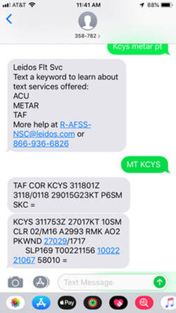
Pilots are able to request and receive METAR, TAF or Adverse Condition Update (ACU) reports via text message from Leidos Flight Service (1-800-992-7433) using the following key words: ACU, METAR, TAF.
Text METAR KCYS to 358-782 (FLT-SVC) and you will get the current METAR for KDEN.
Text METAR KCYS PT to 358-782 (FLT-SVC) and you will get the current METAR for KCYS in Plain Text.
You can combine combine key words:
Text MT KCYS to 358-782 (FLT-SVC) and you will receive current METAR and TAF for KCYS.
Aviation Weather
(affiliated with the NOAA): This site, operated by the National Oceanic and Atmospheric Administration, provides current and forecasted weather, radar and satelitte reporting, prog charts, TAF and Area Forecasts, Pilot Reports and more.
How to Obtain A Good Weather Briefing: Tips on how to get a good weather briefing.
Prevailing Winds (provided by weather.gov): Winds in the upper levels will blow clockwise around areas of high pressure and counterclockwise around areas of low pressure. The speed of the wind is determined by the pressure gradient. The winds are strongest in regions where the isobars are close together.
